WeatherHurricane

Actions

Category 4 Hurricane Helene nears Florida Panhandle; Tornado watch for Treasure Coast until 8 p.m.

All of Palm Beach County and Treasure Coast under tropical storm warning, flood watch
Hurricane Helene
Posted
and last updated

WATCH LIVE COVERAGE FROM WPTV AND SCRIPPS NEWS BELOW:

A tornado watch is in effect for Martin, St. Lucie, Indian River and Okeechobee counties until 8 p.m. Thursday as dangerous Hurricane Helene — now a Category 4 storm — speeds toward Florida's Gulf coast.

The tornado watch for Palm Beach County was canceled just before 5 p.m.

Damaging hurricane winds and catastrophic storm surge are expected to begin in the Florida Big Bend region this evening.

Helene is expected to further strengthen before making landfall in Florida's Big Bend region at approximately 9 p.m. Thursday with 130 mph winds.

According to a 6:20 p.m. update from the National Hurricane Center, Helene now has maximum sustained winds of 130 mph, moving north-northeast at 23 mph.

TRACKING THE TROPICS: Hurricane Center | Hurricane Guide

Helene

TRACKING THE TROPICS: Hurricane Center | Hurricane Guide

Helene triggered multiple tornado and severe thunderstorm warnings in Martin, St. Lucie and Okeechobee counties on Thursday morning.

Helene is a very large hurricane with hurricane-force winds extending outward up to 60 miles from the center and tropical storm-force winds extending outward up to 345 miles.

The strongest winds reported so far in our area were at the Juno Pier with sustained tropical storm-force winds of 40 mph and a gust of 67 mph. Vero Beach saw a 59 mph Thursday morning.

A weather station in Tarpon Point in Sarasota County recently reported a sustained wind of 41 mph with a gust of 54 mph.

"It's getting into the eastern Gulf waters where, eventually, the wind shear that it's dealing with will decrease. And also the fact that it's very warm in this area, it's going to upgrade to a major hurricane," WPTV First Alert Weather meteorologist Jennifer Correa said.

In addition to the tropical storm warning, our entire viewing area is under a flood watch through Friday morning.

"It's going to be quite blustery," WPTV First Alert Weather meteorologist Steve Villanueva said. "And we could pick up some very heavy rainfall, too, as some of those feeder bands roll on through."

watcheswarnings.jpg

"The wind field — when it comes to tropical storm force winds — extends over 300 miles," Correa said. "That's why we're under that tropical storm warning locally."

The Big Bend region and parts of the Florida Panhandle are under a hurricane warning.

After making landfall, Helene is expected to weaken and slow down, then turn toward the northwest over the southeastern U.S. on Friday and Saturday.

Our viewing area will feel impacts from Helene on Thursday and Friday. Helene's outer bands will bring the threat of severe weather, gusty winds and heavy downpours.

helene 4.png

"We might night get too much rain — even though we're under a flood watch — just because we tend to get a huge break in between these rain bands," Correa said. "So we might not see much rain for quite some time, and then all the sudden, it picks up and doesn't last too long."

Villanueva added that the heaviest rain will likely stay on the western side of Lake Okeechobee and toward the west coast of Florida.

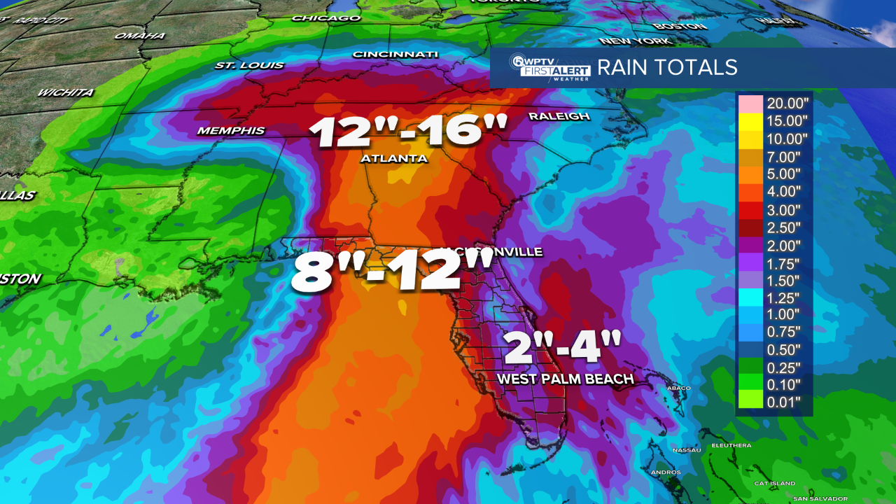
The outer rain bands may spin up a tornado locally and possibly produce two to five inches of rain. And even though Helene will stay roughly 300 miles to our west, the winds can still kick up here locally between 40 to maybe 50 mph.

Most of our viewing area is under a marginal risk of severe weather — the lowest tier — on Thursday. However, Okeechobee County and the northern Treasure Coast are under a slight risk, according to the Storm Prediction Center.

"That means we do have a chance of seeing those tornadoes develop as the afternoon wears on," Villanueva said.

For Friday, a lot of tropical moisture will continue to move across South Florida. It won't be as windy, but still quite breezy.

By the weekend, storm chances will drop to more seasonal levels.

Read more of WPTV's coverage of Hurricane Helene below:

A tree falls onto a home in the 400 block of Southeast Cortez Street near Stuart on Sept. 26, 2024.jpg

Hurricane

HELENE'S IMPACT: Family rescued after tree destroys home in Martin County
Matt Papaycik
classroom-classrooms generic-students-chidren-school-desk (1).png

Tropical Weather

Palm Beach Co., Treasure Coast schools closed Thursday
Matt Papaycik
46468979-1-5 day qpf_Rain Totals Florida.png

Tropical Weather

COUNTY-BY-COUNTY IMPACTS: What to expect

Audra Schroeder
SW TRACKING HELENE Steve Weagle.png

Hurricane

Steve Weagle: Here's what you need to know about Helene

Steve Weagle
Tropical Weather

Hurricane

Helene threatens 'unsurvivable' storm surge and vast damage, forecasters say

Heather Hollingsworth and Stephen Smith, Associated Press

Hurricane

'Cautiously optimistic': Wellington prepping for potential flooding

Michael Hoffman

Hurricane

'WAITING AND WATCHING': Belle Glade, South Bay preparing for impacts of Helene

Matt Sczesny

Hurricane

Big Bend residents pray ahead of Hurricane Helene

Joel Lopez

WPTV First Alert Weather Spotters Sponsored By: Manatee Lagoon

About WPTV NewsChannel 5

Join WPTV First Alert Weather Spotters team

Jonathan Diego

Hurricane

Hurricanes Frances and Jeanne: 20 Years Later

JAMES_SURF_FORECAST_webgraphic.png

Surfing Blog

Surf Forecast: Helene in the Gulf

James Wieland

2024 STORM NAMES

Alberto

Beryl

Chris

Debby

Ernesto

Francine

Gordon

Helene

Isaac

Joyce

Kirk

Leslie

Milton

Nadine

Oscar

Patty

Rafael

Sara

Tony

Valerie

William

TERMS TO KNOW

TROPICAL STORM WATCH: An announcement that tropical storm conditions (sustained winds of 39 to 73 mph) are possible within the specified coastal area within 48 hours.

TROPICAL STORM WARNING: An announcement that tropical storm conditions (sustained winds of 39 to 73 mph) are expected within the specified coastal area within 36 hours.

HURRICANE WATCH: An announcement that hurricane conditions (sustained winds of 74 mph or higher) are possible somewhere within the specified coastal area. A hurricane watch is issued 48 hours in advance of the anticipated onset of tropical-storm-force winds.

HURRICANE WARNING: An announcement that hurricane conditions (sustained winds of 74 mph or higher) are expected somewhere within the specified coastal area. A hurricane warning is issued 36 hours in advance of the anticipated onset of tropical-storm-force winds.