


WEST PALM BEACH, Fla. — We're just days away from the peak of hurricane season, and so far, we've only had five named storms during what was expected to be an extremely active season.
Before the season officially started on June 1, the National Oceanic and Atmospheric Administration had predicted 17 to 25 named storms, eight to 13 hurricanes, and four to seven major hurricanes of Category 3 strength or greater.
Colorado State University — considered one of the top predictors of hurricane season — called for 23 named storms, 11 hurricanes, and five major hurricanes.
An average season sees approximately 14 named storms, seven hurricanes, and three major hurricanes.
"We're only halfway through the season, so we have a few more weeks to go. But we are, at this point, below normal with hurricane and tropical storm activity," WPTV First Alert Weather chief meteorologist Steve Weagle said in a video posted on the WPTV Instagram page.
TRACKING THE TROPICS: Hurricane Center | Hurricane Guide
As of Friday, the National Hurricane Center is watching four areas of unsettled weather for possible tropical development, but all of them have low chances of formation and don't pose any threat to South Florida.
Weagle said most models don't pick up on anything developing in the short-term.

"The models for the next two weeks also suggest that it will be quiet," Weagle said, adding that things in the tropics have "really kind of shut down."
So what's happening, especially after the season started in historic fashion with a monster Category 5 Hurricane Beryl in late June, which was the first storm on record to strengthen into a Category 5 in the Atlantic Basin that early in the season.
Weagle said a number of factors are behind the lag in hurricane season activity, with one of the most notable being that La Niña — a climate pattern that can encourage hurricane activity — never formed, as was expected in late July or August.
"It's not here yet. And it may never get here through this year's hurricane season. Usually it enhances tropical storm activity. It's not around," Weagle said.
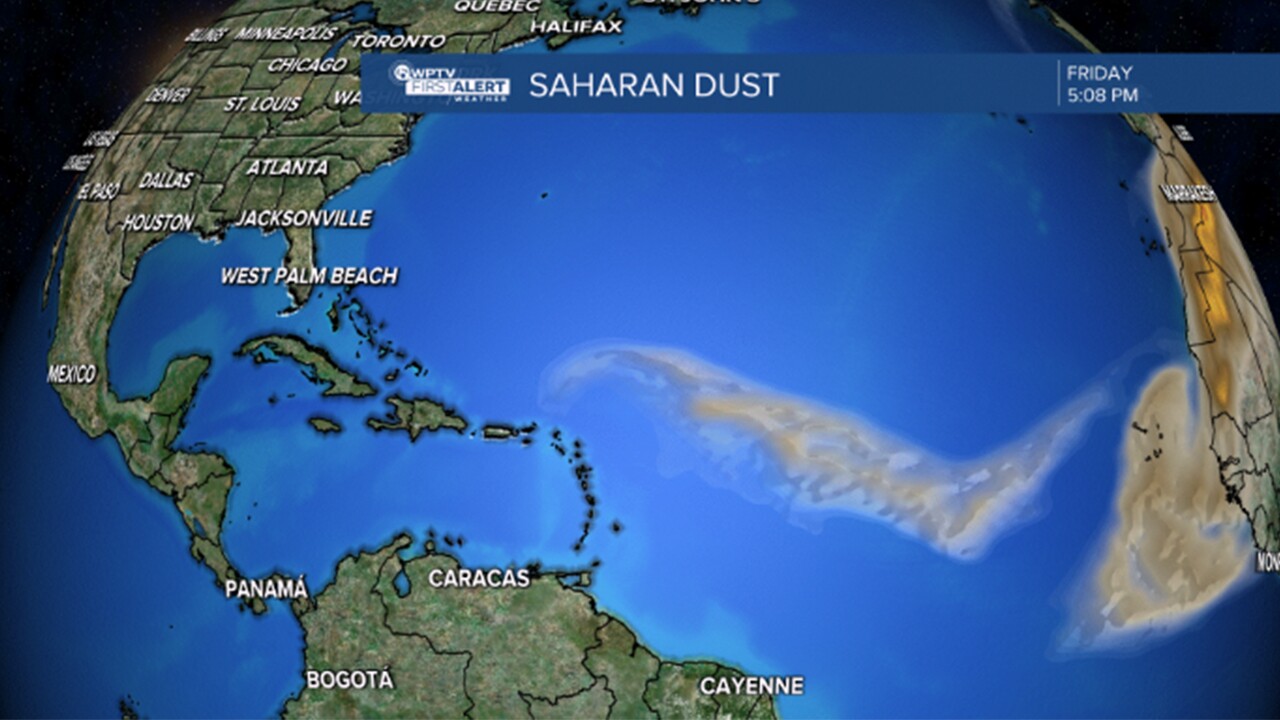
Another big factor, according to Weagle, is the presence of Saharan dust from Africa that has swept across the Atlantic this season, drying out parts of the atmosphere and preventing tropical systems from forming, even as we deal with record-breaking warm water.
Finally, Weagle said the Madden-Julian Oscillation — a weather disturbance of rain, clouds, and wind that pushes across the tropics and enhances tropical activity — has not yet moved into the Atlantic Ocean or Caribbean Sea, and thus has not had any direct impacts on our hurricane season.
"Right now, it's in the Pacific Ocean. It's around the Philippines and southeast Asia. So it's not going to have an impact either, at least not in the short-term," Weagle said.
The peak of the Atlantic hurricane season is Sept. 10, and the season officially ends on Nov. 30.
But as always, you want to stay prepared throughout the entire season. You can find a list of resources and information to stay storm ready on the free WPTV Hurricane Guide.


