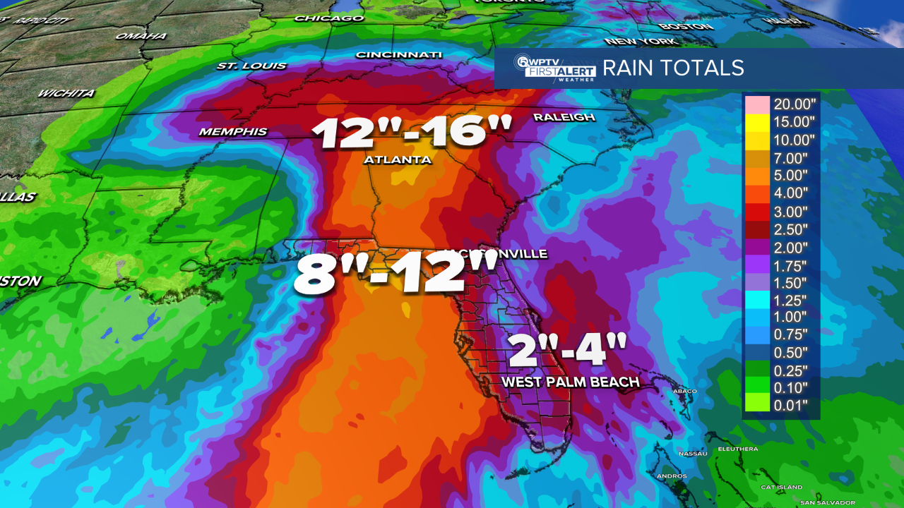
WEST PALM BEACH, Fla. — Helene remains a Category 1 hurricane and is expected to bring catastrophic winds and storm surges to the Gulf Coast and Big Bend region of Florida.
All of Palm Beach County and the Treasure Coast are under a tropical storm warning as Helene barrels north and approaches the Sunshine State.
In its 2 a.m. update, the National Hurricane Center said Helene has maximum sustained winds of 85 mph and moving north at 12 mph.

TRACKING THE TROPICS: Hurricane Center | Hurricane Guide
Helene is now expected to strengthen into a major Category 4 hurricane before making landfall in Florida's Big Bend region at about 8 p.m. Thursday with 130 mph winds.
"It is becoming more organized," WPTV First Alert Weather meteorologist Steve Villanueva said. "And as it heads into the Gulf of Mexico, there's very little wind shear and very warm water. So this storm system is expected to become stronger and stronger."

The NHC has placed Palm Beach, Martin, St. Lucie, Indian River and Okeechobee counties under a tropical storm warning, meaning tropical storm conditions are expected somewhere within the warning area within the next 36 hours.
In addition, Palm Beach County is under a flood watch.
The center of the storm will stay roughly 300 miles to the west of West Palm Beach.
The Big Bend region and parts of the Florida Panhandle are under a hurricane warning.
After making landfall, Helene is expected to weaken and slow down, then turn toward the northwest over the southeastern U.S. on Friday and Saturday.
Our viewing area will feel impacts from Helene between Wednesday and Friday.
We'll start to see the outer bands on Wednesday as storm moves into Gulf. That will continue into Thursday with the threat of severe weather, gusty winds and heavy downpours.

For South Florida, the heaviest downpours will likely be into Thursday morning.
"As we head into Thursday, most of the heaviest downpours will stay along the Gulf coast, and for us it's going to be more scattered about," Villanueva said.
The outer rain bands may spin up a tornado locally and possibly produce two to five inches of rain. And even though Helene will stay roughly 300 miles to our west, the winds can still kick up here locally between 40 to maybe 50 mph.

For Friday, a lot of tropical moisture will continue to move across South Florida. It won't be as windy, but still quite breezy.
By the weekend, storm chances will drop to more seasonal levels.
Read more of WPTV's coverage of Hurricane Helene below:

Tropical Weather
Palm Beach Co., Treasure Coast schools closed Thursday

Tropical Weather
COUNTY-BY-COUNTY IMPACTS: What to expect

Hurricane
HURRICANE HELENE: Palm Beach Co., Treasure Coast under Tropical Storm Warning

Hurricane
Steve Weagle: Here's what you need to know about Helene

Hurricane
'Cautiously optimistic': Wellington prepping for potential flooding

Hurricane
'WAITING AND WATCHING': Belle Glade, South Bay preparing for impacts of Helene

Hurricane


